


TECHNICAL BACKGROUND
The Northeast Ocean Data Portal website at northeastoceandata.org serves as a shared source of peer-reviewed regional data and information to support decision-making by government and non-government entities, and activities of the many stakeholders who interact with the ocean. Website users can launch interactive Theme Maps on key topics, define any custom combination of data on the Data Explorer map, download data, and browse a directory of other mapping tools and data sources. This page presents an overview of the technical architecture behind the website. For a general, non-technical overview of Northeast Ocean Data, see About > Overview.
DATA SOURCES AND DATA PROCESSING
 The Northeast Ocean Data Working Group builds and shares data products based on users’ needs, data availability, and priorities of the Northeast Regional Ocean Council and the Northeast Ocean Plan. Many Portal users are interested in themes such as marine transportation, energy, or marine life, and the Portal’s maps and data are organized to align with the Northeast Ocean Plan.
Numerous government agencies and non-government organizations contribute data to the Portal. All datasets and draft versions of maps are reviewed rigorously by many people such as agency staff, subject matter experts, and knowledgeable stakeholders before being added to the Portal. This process ensures that the data have the necessary level of accuracy, and that maps portray the data appropriately and in a useful format. For example, the U.S. Coast Guard provided data on vessel traffic, draft versions of interactive maps were reviewed by USCG staff and members of the marine transportation industry, and the Northeast Ocean Data Working Group revised the maps based on the reviewers’ comments.
In many cases, data providers host datasets themselves and publish web map services that the Portal uses to incorporate the data dynamically into maps. This enables data providers to retain control over maintaining and updating the datasets. In other cases, the best solution is for data to be hosted directly on the Portal’s server. The Northeast Ocean Data Working Group analyzes and processes the data as needed before putting them on the website. For some types of data, records are converted, digitized, and integrated from original or multiple sources.
Most of the Portal’s product development and integration efforts are conducted by scientists and analysts working together on desktops using tools such as MatLab and ArcGIS. A local projection such as the UTM 18 or 19 is used in original development, and datasets are documented using the FGDC CSDGM specification. Whenever possible, the Portal offers datasets as downloadable files.
TECHNICAL ARCHITECTURE
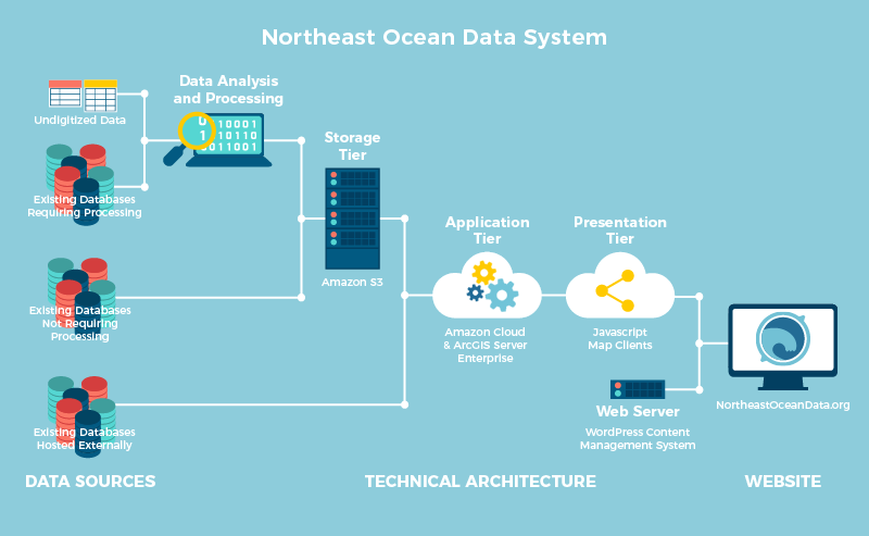
The Northeast Ocean Data Portal system is based on an n-tier design. It has three main components: (1) a storage tier, which principally includes Amazon S3 hardware, (2) an application tier, which is driven by a large (4 CPU) Amazon machine instance and ArcGIS Server Enterprise, and (3) a presentation tier, composed of JavaScript map clients.
MAP SERVICES
The Portal publishes map services that are hosted on its cloud account. The map services are used to populate the Portal’s various map viewers and are available publicly for use in other mapping applications. When a dataset is completed and ready for distribution, that “feature class” is converted to the Web Mercator projection, cartographically rendered, and included in a map service file. The file is then transferred to the Portal’s S3 storage tier and to the application host. Using ArcGIS Server administrative tools, the service is then configured and engaged to publish dynamically rendered images using a REST-based web services protocol. All of the Portal’s maps are displayed as layers on top of base maps hosted by either Esri or NOAA.
WEBSITE

The Northeast Ocean Data website uses WordPress as its framework and content management system (CMS). The interactive maps from map services are incorporated into a WordPress wrapper for display on the site. Content and maps are developed and revised on a development site and then pushed to a staging site when completed and to the production site for public release.
